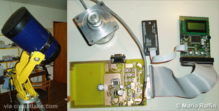
Telescope Control System
This M16C/62P microcontroller-based electronic interface controls the view direction of a telescope. It displays the celestial coordinates of framed area of the sky with good accuracy on LCD. The system also can be interfaced with a Personal Computer via RS232 and use PC software like SkyCharts to display the coordinates.
One of the main concepts involved with this telescope controller project is the definition of celestial coordinates. It is basically a spherical coordinate system where each object in the sky is supposed to lay on the celestial sphere, an imaginary sphere of “gigantic radius”, concentric with the Earth. This sphere does not rotate with the earth so that all the stars have a constant position on this sphere.
The right ascension is the angular distance measured eastward along the celestial equator between a reference point (vernal equinox) and the hour circle intersecting the point. The right ascension is measured in hours, minutes, and seconds from 0 to 24 hours. If you are looking at it from the North Pole, it is measured in a counterclockwise direction.
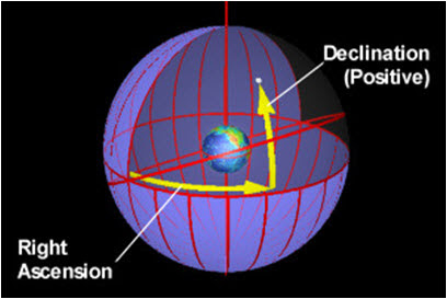
The declination of a point is the angular distance above or below the celestial equator. It is measured in degrees, minutes, and seconds from -90 to +90 degrees with 0 being on the celestial equator. Negative degrees indicate that the point is south of the celestial equator, while positive degrees indicate that it is north of the celestial equator. A coordinate of -90 degrees declination indicates that the point is on the south celestial pole while +90 degrees indicates that it is on the north celestial pole.
After a procedure called “stationing”, the two axes of a telescope (with equatorial mounting) move along the Right Ascension and the Declination coordinates.